


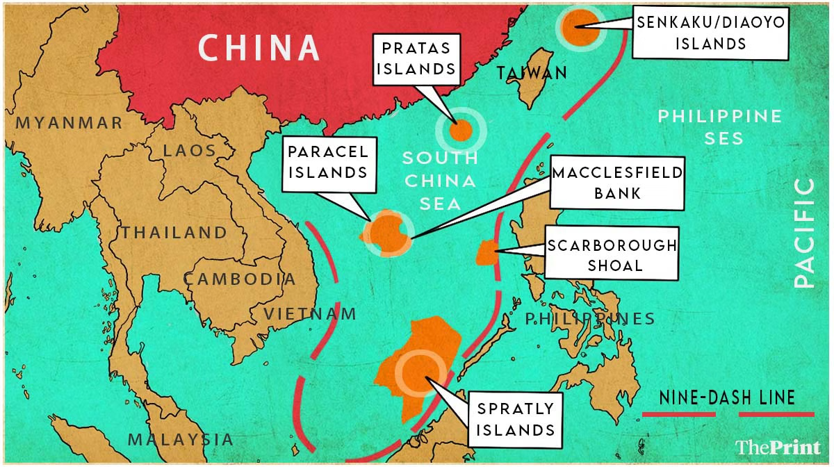
The South China Sea (SCS) is an epicenter of global strategic competition, contested by seven entities and recognized as the world’s most disputed water body. The conflict centers on sovereignty over tiny islands, small rocks, and submerged reefs, which claimants fight to occupy, build bases upon, and in some cases, transform into artificial islands. For the People’s Republic of China (PRC), its expansive claim, codified by the nine-dash line, is a matter of historical right, critical strategic necessity, and modern national identity. This analysis explores the historical foundations, crucial strategic drivers, and current legal dimensions that solidify China’s resolute position in the South China Sea.
Historical Roots: From Maritime Trade to Claim Precedent
China’s deep connection to the South China Sea is the primary justification Beijing cites for its claims, framing the dispute through a historical lens spanning millennia.
Early Chinese Presence and Seafaring
Historical evidence confirms China’s long-standing presence in the area. Maps dating back to the early 1600s, like one commissioned by a wealthy Chinese merchant, show surprisingly accurate details of the region, emphasizing China as a powerful seafaring civilization. The inclusion of major island groups and trade routes extending into Southeast Asia and the Indian Ocean underscores centuries of Chinese maritime activity. Furthermore, the discovery of Chinese artifacts—pottery, bowls, and coins—by archaeologists on the islands proves that merchants and fishermen regularly used these features for shelter and sustenance.
You May Like To Read: UN Security Council Set for Pivotal Vote on Gaza Stabilization Force
However, historical context suggests the imperial Chinese government viewed these isolated features as “rocks in the middle of the ocean” and did not exercise the kind of continuous, exclusive sovereign control required for a modern claim. This evidence, therefore, demonstrates trading patterns and discovery, but its translation into modern ownership remains a central point of contention.
The Geopolitical Revaluation
The status of these islands fundamentally changed in the 20th century. European colonization, particularly the arrival of the French navy to Indochina (now Vietnam), brought foreign powers into direct conflict with China over the islands. By the 1930s, the French formally claimed the features, escalating tensions that included Japan.
World War II was the geopolitical crucible that cemented the islands’ strategic value. Japan rapidly seized the entire region, turning the South China Sea into a “Japanese lake” and recognizing the islands’ potential for military uses, such as seaplane harbors and submarine docks. When the United States defeated Japan, forcing it to relinquish all conquered territory, it became immediately clear that the small, rocky islands were suddenly critically important strategic locations at a global crossroads. The post-war scramble saw countries, including China, Vietnam, and later the Philippines, urgently staking claims, realizing that a failure to do so meant losing the territory to a rival.
The Genesis and Symbolism of the Nine-Dash Line
The core of China’s modern territorial assertion lies in a demarcation drawn during a moment of domestic turmoil.
The 11-Dash Line of 1947
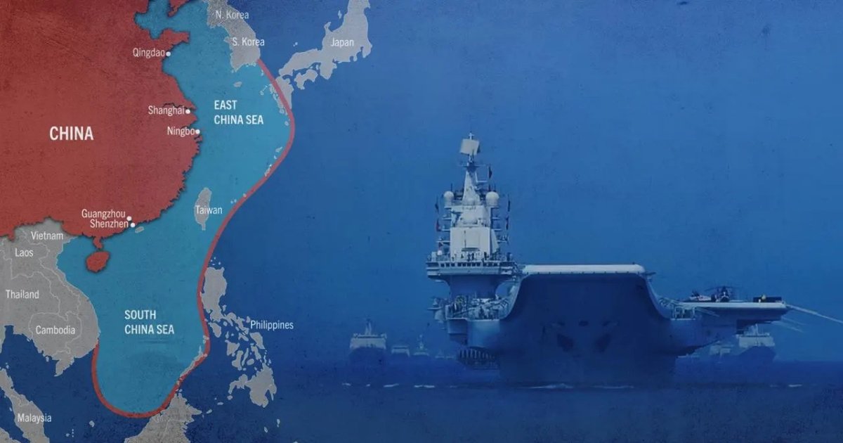
The foundational map emerged in the late 1940s, during China’s civil war. The Nationalist government (Republic of China, ROC), then fighting the communist revolution, asserted sovereignty over the islands. Following a December 1946 expedition to plant a flag on a Spratly Island, the ROC government released an official map showing an 11-dash line drawn around the periphery of the entire South China Sea. This map formally asserted that the waters “has always been ours and remains ours,” relying on historical references and an old 1936 Atlas for definition.
After the communist victory, both the new PRC mainland government and the exiled ROC government in Taiwan adopted the line, though the PRC later removed two dashes as a gesture of comradeship toward North Vietnam, resulting in the nine-dash line used today. This U-shaped line is more than a legal boundary; it is a potent national symbol printed in every Chinese passport and woven into the fabric of the country’s patriotic education, signifying the recovery of “lost” territory.
Strategic Drivers and Escalation
The relentless competition over the SCS is driven by three primary strategic factors: its role as a global shipping artery, its rich fishing resources, and its immense hydrocarbon potential.
The Oil Rush and Military Confrontation
The SCS contains critical shipping lanes through which an estimated $3.37 trillion of global trade passes annually, making it vital for global commerce. It is also one of the world’s most productive fishing grounds. The acceleration of military confrontation, however, began with the discovery of oil and natural gas in the late 1960s, with estimates suggesting billions of barrels of oil and over 190 trillion cubic feet of natural gas.
The pursuit of these resources led to direct military clashes. When South Vietnam worked with foreign companies to drill, China began drilling in the Paracels. In 1974, a clash occurred after South Vietnamese forces attempted to expel Chinese fishermen. China responded by deploying naval vessels and jets, decisively taking full control of the Paracel Islands and establishing a permanent military presence. This clash, which killed 70 Vietnamese troops, established the precedent of using military might to secure claims. Since then, the region has filled with bases and outposts established by multiple claimants, all fighting for resources, control over shipping, or strategic military placement.
International Law, The Arbitration, and Gray Zone Tactics
China’s claim stands in direct opposition to the primary legal framework governing the world’s oceans.
UNCLOS and the Arbitration Ruling
The UN Convention on the Law of the Sea (UNCLOS) was designed to create rules for maritime boundaries, allowing states a 12-nautical-mile territorial sea and a 200-nautical-mile Exclusive Economic Zone (EEZ) for resource exploitation. China is a signatory to UNCLOS, but its expansive nine-dash line claim simply does not fit this framework, as it overlaps significantly with the EEZs of its neighbors.
In 2016, the Philippines formally challenged the claim at the International Court of Arbitration in The Hague. The court delivered an overwhelming ruling in favor of the Philippines, declaring that China’s nine-dash line had no legal basis under UNCLOS. The ruling further clarified that human modifications cannot change the legal status of features, and artificial islands or structures cannot generate territorial seas or EEZs.
China refused to participate in the proceedings and immediately rejected the ruling, calling it “null and void” and a “political farce.” This rejection stems from China’s deeply held belief that its historical narrative supersedes modern treaty law, maintaining that it was the first to discover and exercise sovereignty over the islands.
Gray Zone Coercion and Militarization
Since the 2016 ruling, China has increasingly relied on “gray zone” tactics—coercive actions that fall short of conventional warfare—to assert control and erode the sovereignty of rival claimants.
-
Maritime Militia and Coast Guard: China uses its massive, state-funded maritime militia and its powerful China Coast Guard (CCG) to swarm, harass, ram, and use high-pressure water cannons against Philippine resupply and civilian vessels at flashpoints like the Second Thomas Shoal. These actions are designed to assert control without provoking a military response.
🚨🇨🇳🇷🇺 China and Russia begin joint naval drills in the South China Sea, with state media calling it a message to “countries fueling tensions” — a clear reference to the US. pic.twitter.com/DTQQPAFvcM
— Defense Intelligence (@DI313_) November 16, 2025
-
Artificial Island Building: China has engaged in massive dredging and land fill operations to transform submerged reefs and small features into full-scale artificial islands, building military bases, runways, and radar systems on them. This process has caused severe and irreversible ecological damage, destroying vast areas of coral reef ecosystem. While the 2016 ruling clarified these cannot generate territorial rights, they serve as crucial military and logistical hubs to support China’s long-range patrols and gray zone operations.
-
Recent Developments (2024-2025): The situation remains volatile. China introduced new territorial sea baselines in the Gulf of Tonkin in 2024, while the Philippines submitted a claim for an extended continental shelf beyond 200 nautical miles west of Palawan to the UN. These moves, alongside the commissioning of China’s third aircraft carrier, the Fujian, and increased multilateral defense cooperation between the Philippines, Canada, and Australia, underscore a rising tide of tension and a hardening of positions across the region.
Conclusion: A Matter of National Rejuvenation
China’s claim to the South China Sea is viewed domestically as a non-negotiable component of its national resurgence. The dispute is not solely a calculation of oil reserves or trade routes; it is inextricably linked to the political concept of the “great rejuvenation of the Chinese nation”—a core objective for the leadership.
For China, asserting the nine-dash line is a symbolic reversal of the historical “Century of Humiliation,” where foreign powers seized Chinese territory and eroded its sovereignty. Maintaining this claim, even in the face of international legal rulings and diplomatic pressure, is seen as a sign of a strong, unified nation standing firm on its historical territorial integrity. This deeply ingrained national narrative ensures that the commitment to the SCS will remain a constant and formidable factor in one of the world’s most vital and contested geopolitical arenas.